Public Health Map Shows Overdoses Clustered Around T Stops
A newly release Cambridge overdose map created by the Department of Public Health reveals surprising insights into where overdoses are concentrated in Cambridge.
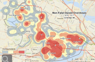
As reported by Cambridge Day, where do people overdose on drugs in Cambridge? Mostly near MBTA subway stops.
We know this because the city’s Public Health Department has, for the first time, drawn a map that shows the concentration of nonfatal opioid overdoses per square mile. Like drops of blood spreading into the surrounding area, the darkest blobs represent the places of highest overdose density. And those areas are near every T station in Cambridge except Kendall, with a couple of other spots along Concord Avenue.
Are You Struggling With Addiction?
Get Relief Now! Call Today To Ask About Our Cutting-Edge Programs.
(833) 596-3502
Maps are an important tool in public health, Anna Wielgosz, manager of the health department unit said. They help officials “appropriately allocate resources to the people and places that need it the most,” she said in a written statement. Mapping can also disclose “previously unknown geographic trends.”
In the case of overdoses, maps such as the charts showing density of nonfatal incidents can help public health officials target prevention efforts, “street outreach,” training for businesses and other resource allocation, Wielgosz said.
Are you or a loved one struggling with addiction, lying to yourself and others? Don’t wait any longer to ask for help. In today’s environment, you never know when your next dose will be your last! Our Neuro Rehabilitation approach helps address the root causes of addiction once and for all.
To learn more about how Cambridge MA is mapping the opioid crisis, please visit Cambridge Day.